3D scanning is transforming the luxury rental market by reducing expenses and improving property management. This technology creates detailed digital models of properties, enabling virtual tours, precise renovation planning, and efficient event management. Key benefits include:
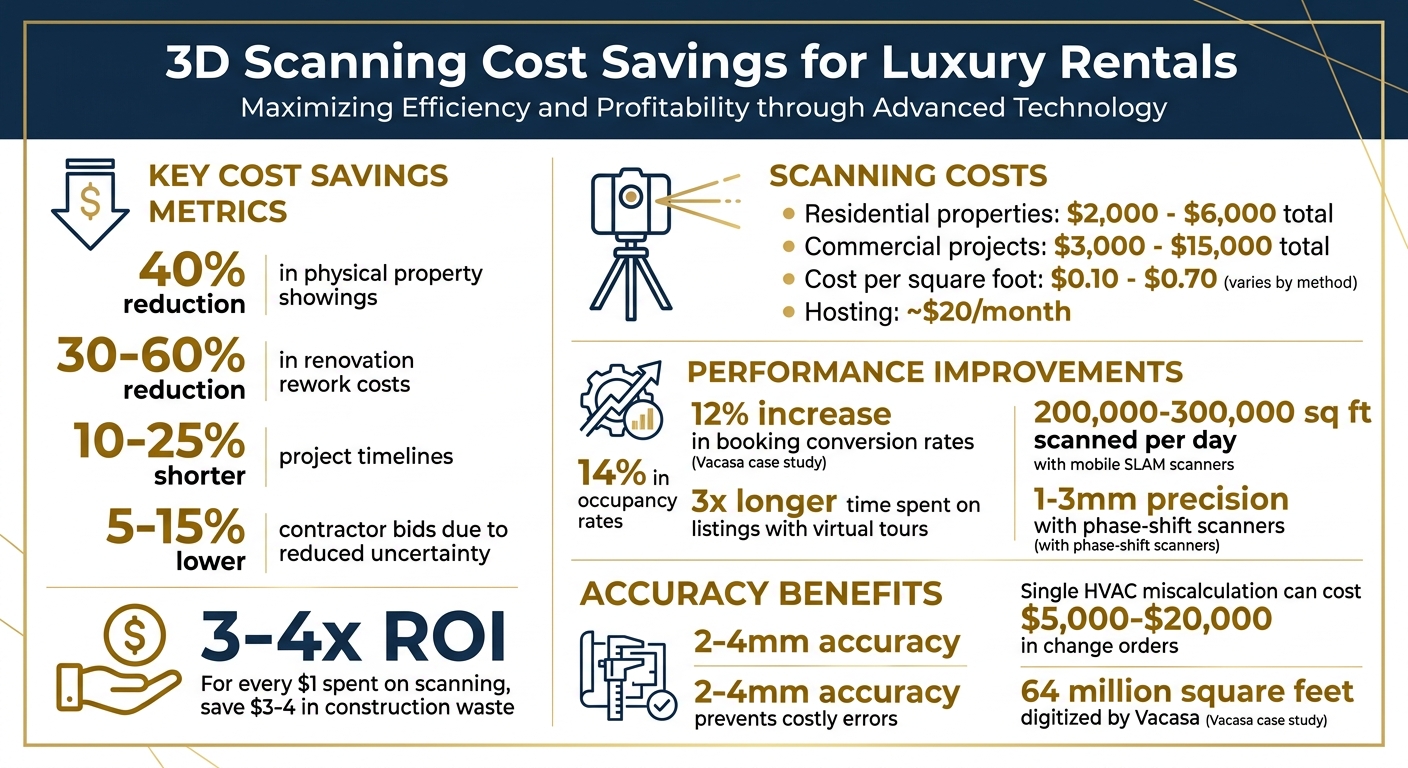
- Virtual Tours: Cut physical showings by up to 40%, saving time and resources.
- Cost Savings: Avoid renovation errors, reducing rework costs by 30–60%.
- Event Planning: Accurate models streamline logistics for venues and film locations.
- Affordable Scanning Services: Costs range from $0.10–$0.70 per square foot, with total project costs typically between $2,000–$15,000.
Luxury property owners use 3D scans to attract international clients, eliminate costly mistakes, and simplify operations. With tools like LiDAR and SLAM scanners, entire estates can be scanned in a day, providing a permanent digital record for future use.
3D Scanning Cost Savings and ROI for Luxury Rental Properties
LiDAR Point Cloud Scan of Luxury Home | 3D Laser Scanning for As-Built Drawings
sbb-itb-161ccc1
How 3D Scanning Reduces Costs
3D scanning offers more than just a way to create virtual tours – it’s a powerful tool for cutting costs across various operational areas. From reducing unnecessary site visits to avoiding expensive renovation mistakes, property owners see real savings. For luxury rentals used as vacation homes, event venues, or film locations, these savings can add up quickly.
Fewer Physical Property Showings
Virtual tours help weed out casual browsers, ensuring only serious prospects schedule in-person visits. In fact, 3D virtual tours can reduce physical showings by up to 40%. This translates to lower operational costs, including less staff time spent coordinating visits, reduced wear and tear on the property, and fewer resources needed to prepare the space.
This benefit is especially valuable for luxury properties targeting international clients. For instance, high-end Manhattan listings priced between $8.9 million and $49.5 million can be toured virtually by potential buyers or renters from anywhere in the world. The 24/7 access allows clients to explore the property at their convenience, often speeding up decision-making.
"A single Matterport tour generates more qualified leads than months of traditional photography. The immersive experience filters out casual browsers and attracts serious buyers who have already explored the space virtually".
The costs of professional 3D scanning services – ranging from $0.20 to $0.70 per square foot, plus about $20 per month for hosting – are relatively small compared to the expenses saved by reducing physical showings. These savings pave the way for even more cost-effective property management practices.
Preventing Renovation and Maintenance Errors
Accurate 3D scans do more than save on showings – they help avoid costly renovation mistakes. For example, a single miscalculated HVAC duct placement could result in change orders costing $5,000 to $20,000. With 3D scanning offering accuracy within 2–4mm, these kinds of errors are virtually eliminated, as design decisions can be based on the property’s actual conditions rather than outdated blueprints.
The financial benefits are clear: for every dollar spent on scanning, property owners save three to four dollars in construction waste. Projects that use 3D scan data see a 30–60% reduction in rework costs and project timelines shortened by 10–25%. Contractors can also submit tighter bids – 5–15% lower – because there’s less uncertainty about field conditions. Additionally, the permanent digital record created by 3D scans serves as a reliable reference for future maintenance, reducing the need for repeated site visits and further boosting ROI for luxury rental properties.
Easier Event and Film Location Management
For properties used as event venues or film locations, 3D scanning simplifies logistics while cutting setup errors. Event planners and production teams can access highly accurate digital models that include essential details like ceiling heights and outlet placements, all without requiring multiple site visits. These precise digital records reduce travel expenses and speed up booking processes.
Mobile SLAM scanning, which can document 200,000–300,000 square feet per day, is particularly effective for large estates. Costs for commercial scanning projects generally fall between $3,000 and $15,000, with larger facilities benefiting from lower rates of $0.10 to $0.25 per square foot. Deliverables like 2D CAD drawings or 3D BIM models further enhance planning accuracy, minimizing last-minute changes and keeping costs under control for luxury rental owners.
How to Implement 3D Scanning
Getting started with 3D scanning revolves around three main steps: picking the right tools, capturing precise data, and converting those scans into practical formats. Here’s a clear breakdown of how to make the process work smoothly.
Step 1: Choose the Right Scanning Tools
Phase-shift scanners are the go-to choice for high-end projects, offering 1–3mm precision, which is far superior to time-of-flight models. For top-tier accuracy (1.0–1.9mm at 10 meters), options like the Leica RTC360 (around $85,000) or Trimble X12 are excellent. If buying is too pricey, rentals are an option, costing about $743 per day or $3,046 per week.
For larger properties, especially those over 100,000 square feet, mobile SLAM scanners such as the NavVis VLX 3 are more practical. These can cover 200,000–300,000 square feet daily at a cost of $0.10–$0.30 per square foot, though accuracy dips slightly to 3–5mm. This makes them ideal for cases where speed is more critical than pinpoint precision.
Don’t forget the supporting equipment. Essential items include 145mm high-visibility spheres or checkerboard targets for scan alignment, a tablet for real-time verification, and processing software like Leica Cyclone or Autodesk ReCap. A mid-size project (about 25,000 square feet) could generate 50–150 GB of raw data, so a powerful workstation is non-negotiable. Investing in the right tools upfront reduces errors and eliminates unnecessary return visits.
Once the tools are ready, it’s time to gather the data.
Step 2: Conduct Accurate Scans
Timing matters – schedule scans during peak daylight hours to capture clear textures and accurate dimensions. Clear out clutter to minimize noise in the point cloud.
Make sure each scan position overlaps with the next by at least 30%, ensuring the software can seamlessly align the data. Modern scanners can complete a 360-degree scan in just 2–3 minutes, capturing 1–2.2 million measurements per second. Use your tablet to review scans on-site, catching any gaps immediately to avoid costly repeat visits.
Watch out for reflective surfaces like mirrors or polished metals, which can create "phantom points" that distort the data. Similarly, dark surfaces like black rubber can cause weak signals, leading to gaps. Aim for a 2–3mm registration accuracy – about the thickness of a nickel. This level of precision ensures fewer mistakes and helps keep costs down.
Once the scans are complete, the next step is turning them into usable formats.
Step 3: Create Virtual Tours and Models
Start by processing the raw data. Use registration to align the scans and cleanup to remove artifacts like reflections or temporary objects. For the best accuracy (1–2mm), rely on target-based registration with physical spheres.
To create photorealistic virtual tours, overlay HDR panoramic photographs onto the point cloud. Export the final results using formats like E57, RCP, or OBJ, which are widely compatible. Tools like TruView allow stakeholders to explore the property directly through a browser, no extra software required.
If you need CAD drawings or BIM models, hiring professionals typically costs $0.50 per square foot. For residential properties, total scanning costs usually range from $2,000 to $6,000, while commercial projects can cost anywhere between $3,000 and $15,000. Professional training for advanced systems is available for around $2,985, though shorter sessions for specific tasks, like cleaning up data, are priced at about $450 for two hours. This focus on precision and efficiency translates directly into cost savings by avoiding errors and unnecessary site visits.
Real-Life Applications of 3D Scanning
Improving Guest Experiences with Virtual Tours
Since 2015, Vacasa has integrated Matterport 3D tours into nearly 90% of its 38,000+ properties. The results? Properties with these virtual tours saw a 12% jump in booking conversion rates, and guests spent three times longer browsing these listings compared to those with standard photos. Additionally, occupancy rates across the portfolio rose by 14%.
One of the key benefits of this technology is how it addresses common booking concerns. Guests can remotely verify spatial details, ensuring the property meets their needs. For instance, they can check if a pack-and-play fits in a particular room or confirm that a dining table seats their entire group. The interactive Dollhouse View provides a 3D model of the property, offering clarity on room layouts – like how close the kids’ rooms are to the master suite. This level of transparency significantly reduces complaints stemming from unmet expectations.
"The 3D tour converts the click into a booking, because the guest can answer every spatial question themselves before they commit." – James Richardson, Southeast 3D Tours
Vacasa’s customer support teams also benefit from these digital tools. By using the virtual property layouts, agents can guide guests remotely, helping them locate an electrical panel or find specific amenities – eliminating the need to send staff on-site. To date, Vacasa has digitized over 64 million square feet of rental space using this method.
And the applications don’t stop at guest bookings – 3D scanning is also transforming event planning and film location management.
Better Event Planning with Accurate Models
For event planners and location scouts, 3D models eliminate much of the guesswork. These tools allow them to confirm space capacities – like seating arrangements or accommodating additional equipment – without needing multiple site visits.
When planning a wedding or corporate retreat, sharing a 3D tour link enables all stakeholders to explore the venue on their own time. This convenience shortens the decision-making process from days to just hours. Features like the Dollhouse View also make it easier to understand indoor-outdoor flow, which is crucial for flexible event layouts.
At Essentialyfe, where properties double as event venues and filming locations, this technology simplifies coordination for clients assessing spaces for productions or celebrations.
"Thanks to Matterport, our agents can instantly view a property layout to address guest inquiries, which accelerates problem-solving." – Caleb Donegan, Vice President of Digital, Vacasa
The Future of 3D Scanning in Luxury Rentals
3D scanning is transforming the way luxury rental properties are managed, offering faster results, reduced costs, and improved accessibility. Take mobile SLAM scanners like the NavVis VLX3, for example – they can map an impressive 200,000 to 300,000 square feet in a single day. This means entire estates can be digitized in just 1–3 days, significantly cutting labor costs and minimizing guest interruptions.
The creation of a permanent digital twin through these scans eliminates the need for repeated site visits. Property managers can access the virtual model anytime to plan renovations, confirm measurements for events, or address maintenance concerns. For multi-use properties – such as Essentialyfe’s luxury vacation homes that double as event venues and film locations – this digital capability simplifies operations across various services.
"The resulting point cloud also serves as a permanent digital record that can be revisited for future measurements without returning to the site." – THE FUTURE 3D
As the technology advances, it’s becoming more affordable. Mobile SLAM scanning now costs about $0.10–$0.25 per square foot, compared to the $0.30–$0.70 range of traditional methods. Full scans of luxury homes typically fall between $2,000 and $6,000, making this technology a practical option even for smaller portfolios.
But it’s not just about cost – accuracy has also seen major improvements. With precision now at ±3–5mm, property owners can confidently use these scans for tasks like furniture placement or documenting intricate MEP (Mechanical, Electrical, and Plumbing) systems. This level of detail minimizes errors during renovations and enhances guest satisfaction, whether the property is hosting vacationers, weddings, or film crews.
FAQs
How do I know if 3D scanning will pay for itself on my rental?
3D scanning can be a smart investment, but it’s essential to weigh the costs against the potential benefits. For example, 3D tours often lead to higher booking conversions and improved occupancy rates, which can significantly boost revenue. On top of that, using 3D scanning for inspections and measurements can save time, cutting down on operational expenses. If the added revenue and cost savings surpass the initial investment, the technology could essentially pay for itself.
What should I prepare before a 3D scan to avoid bad results?
For top-notch 3D scans, it’s crucial to prep your space properly. Start by improving the lighting – turn on all the lights and let in natural light by opening blinds or curtains. Make sure the area is tidy and free of clutter. Clear off surfaces, remove personal items, and keep closet doors closed unless they need to be part of the scan. In kitchens and bathrooms, empty the sinks and neatly arrange toiletries. A clean, well-lit, and organized setting will help ensure precise and high-quality results.
Which scan deliverable do I actually need: virtual tour, CAD, or BIM?
When choosing the right scan deliverable, it all comes down to your goals. If you’re looking to create an immersive property showcase, a virtual tour is perfect for allowing clients to explore the space in detail from anywhere. On the other hand, for precise architectural documentation or renovation projects, a CAD model is ideal for detailed drawings, while a BIM file provides comprehensive building data. For luxury properties, combining a virtual tour with BIM or CAD delivers both eye-catching visuals and the technical precision needed.